google8d2f7fffcdc71abe.html

The wettest place on earth

“Anything we need to bring on the trip?” The agent at the tourist board office in Shillong in northeast India looked up from her ledger and smiled. It must have been a familiar question.  “I’d recommend umbrellas,” she said matter-of-factly. 

FB cover (2) (600x235).jpg

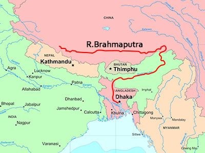
We had booked a day trip to the must-see destination of Cherrapunjee, an area of scenic waterfalls and caves about a two-hour drive south from Shillong near the border with Bangladesh. At 400 rupees ($6 each) it was a bargain. We could have paid more and hired a car, but we prefer traveling with other people. It was raining hard when we left the hotel. I was thinking that Shillong’s “Scotland of the East” label had as much to do with the weather as with the scenery. Technically, Shillong has a sub-tropical highland climate; in practice, that means that during the monsoon season, it rains most days. And some days it rains most of the day. Not the persistent drizzle I remember from hikes in the Lake District, Pennines and Yorkshire Moors, but a steady downpour.

We were the first to board the 30-seater bus and did not notice that our tickets had seat numbers. Other tourists—mostly from Delhi and Kolkata—got on and chose their places. As the bus filled, new arrivals started demanding their assigned seats. The young tour guide who had shown up late was not having much success mediating the seat disputes. People jammed into the narrow aisle or climbed over seats as everyone moved to their assigned places. Eventually, everyone was seated, if not happily. The seating disputes delayed our departure by almost half an hour, and the guide warned us we would have less time at the still-undisclosed number of stops. I wiped the condensation off the window and peered out into the driving rain, wondering if all the seating fuss was worth it because no one could not see much anyway. As we left the outskirts of Shillong, the mist thickened, further obscuring visibility. The road wound through low, grassy hills, with rice paddies in the valleys and terraced rows of tea plants on the hillsides; in places the hills were gouged open for sand, gravel and rock quarries. We passed small churches, with cemeteries on hilltops. 

Our first stop was at a waterfall. “Just 10 minutes, please” the guide said. Stephanie and I surveyed the mist-filled valley and the treacherous, slippery steps descending to the viewing platform, and decided to have a cup of tea instead. We crossed the road to the small “hotel” and claimed a wooden bench. The guide had ordered his breakfast of eggs and Maggi noodles. The other tourists wandered in later, many of them ordering food. The 10-minute stop lasted almost an hour.

Cherra 1.jpg

At the next stop—an ecological park where a waterfall begins its deep plunge—the rain had, if anything, intensified. We almost waded out to the viewing terrace, and looked down to see not mist, but clouds, with the occasional glimpse of the green valley below.

Cherra 2.jpg

Back on the bus, tension was rising. The guide was describing the sights in English, angering two passengers who insisted he speak in Bengali. “It is the official policy to speak in English,” said the guide. Fortunately for him, passengers came to his defense, pointing out that they were Hindi speakers and did not understand Bengali. 

We passed through the small town of Cherrapunjee, a straggle of houses and commercial buildings clinging to the slopes. In the local Khasi language, the settlement was called Sohra; the British called it “Churra,” which may have been how it sounded to them, and eventually it became Cherrapunjee. Today, its main claim to fame is that it is the wettest place in the world, holding the record for the most rainfall in one month (370 inches in July 1861) and in a year (1,042 inches between August 1, 1860, and July 31, 1861). That proved to be too much for even the rain-resistant British administrators, which is why they decamped to the balmier climes of Shillong. Cherrapunjee’s claims are hotly disputed by a nearby Khasi village, Mawsynram, which receives an average of 467 inches a year and got 1,000 inches dumped on it in 1985. “It used to rain every day,” a fellow passenger told me. “Now there are some dry days in December and January. Climate change, I suppose.” Despite all the rain, both places face an acute water shortage and the inhabitants often trek long distances to obtain potable water.

Our next stop, near the rainy village of Mawsynram, was the Mawsmai cave, known for its impressive stalagmites and stalactites. I made it about as far as most of the tourists—the first chamber. The passage ahead was narrow and under several inches of water. My feet were already wet. I figured I’d buy a postcard instead and went back to the bus.   

At the final stop the rain had eased and we looked out towards Nohkalikai Falls, at 1,115 feet (340 meters) the highest plunge waterfall in India, and reportedly the sixth highest in the world. The name in the Khasi language means “jump of Ka Likai." According to legend, a poor woman named Ka Likai struggled to take care of her infant daughter after her husband’s death.  She was forced to re-marry but her jealous new husband killed and cooked up the daughter.  Returning from work as a porter, Ka Likai unknowingly ate the meat and then discovered a severed finger. Distraught, she flung herself over the cliff to her death. 

As usual, mist and clouds blocked the view. Then a breeze moved through the valley, breaking the clouds. And suddenly there it was, the majestic Nohkalikai, plunging into a green pool below. Cameras clicked before the clouds moved in again.

Cherra+3.jpg


Scotland of the East

“Welcome to the Scotland of the East.” The battered road sign on a hairpin curve on India’s National Highway 40 looked incongruous amid the stands of bamboo and sub-tropical vegetation. For a moment, I wondered if I was hallucinating. The scenery didn’t look any different from that Stephanie and I had seen for the past hour as our shared taxi labored up the twisting highway from the Brahmaputra valley into the Khasi Hills, passing villages that looked much like other villages in northeast India. No medieval castles shrouded in mist. No sweeping views of lochs and glens.  No sheep (only the usual cattle and goats on the road). Not a single sprig of heather. And definitely no kilts. But I wasn’t dreaming. The sign contained the imprimatur of the Meghalaya Tourism Board, so at least someone thought we were in Scotland.

FB cover (2) (600x235).jpg

We were on our way to Shillong, the capital of Meghalaya, the small, hilly state sandwiched between western Assam to the north and Bangladesh to the south. The end of the first Anglo-Burmese War in 1826 left the British East India Company in control of Assam and the northeast. The company depended on the river system for transportation, with steamers from Kolkata and other ports carrying troops, supplies, merchants and missionaries up the Brahmaputra. The company’s regional administrator, David Scott, devised a plan to build a road from the plains of Bengal through the hills to the Brahmaputra to provide an alternative route that would not be affected by annual flooding. After a four-year war with the Khasi, the British took control of the hill country south of the Brahmaputra and posted a political agent to the settlement of Cherrapunjee. In 1864, the administration established a hill station at Shillong. A decade later, it became the capital of the province of Assam, and retained its status until 1972 when it became capital of the newly-created state of Meghalaya.

Scotland of East.jpg

The “Scotland” story goes something like this (there is no official version, so I am taking literary license). Reaching the crest of a hill, the East India Company agents, weary from their journey from the sweltering lowlands, looked out through the drizzle on a landscape of grassy, treeless hills, mountain streams and clear lakes. “Reminds me of Ben Lomond,” said one. “Nay, Speyside,” replied another. Either way, it looked like Scotland, or as close to Scotland as homesick, tired and dehydrated East India Company agents could imagine. History—or at least the Meghalaya Tourist Board road sign—would have been different if those first agents had come from the Lake District, Yorkshire, Northumberland or North Wales.

Whatever the origin of the Scotland label, it stuck. At an elevation of almost 5,000 feet, the hill station of Shillong had a mild climate—cool and rainy in summer, cool and dry in winter—offering welcome relief from the searing temperatures of the lowlands. The British planted pine trees, and built Victorian bungalows, churches, a polo ground and a golf course called Gleneagles. For half a century, Shillong resembled a transplanted British country town. Then India crowded in. Today, Shillong with a population of 150,000 is (by Indian standards) a large town; its suburbs, sprawling across the hills, add another 200,000 to the metropolitan area. Khasis make up most of the population, with other northeastern tribes represented, as well as Assamese, Bengalis and migrants from mainland India.

About half the population of Meghalaya, and two thirds of Shillong, listed themselves as Christian on the 2011 census. Protestant and French Catholic missionaries had followed the colonial administrators into the hill country and found willing converts among the tribal peoples, many of whom mixed Christianity with traditional beliefs. Not surprisingly for the “Scotland of the East,” Presbyterians form the largest denomination; they built sturdy stone and timber churches in Shillong and other towns. Immigrants from Assam and mainland India have recently led to a resurgence of Hinduism with about one in four in Shillong listing Hinduism as their religion.

Shillong+church.jpg

The Presbyterians win in the numbers game but it’s the Catholics who win the architectural prize for the Cathedral of Mary Help of Christians, situated on a hill a mile south of the center of Shillong. It is the principal place of worship for the Shillong Archdiocese, which has 33 parishes and an estimated 300,000 adherents. The cathedral stands out not only because of its Art Deco style but because of its color—a striking shade of blue, which also brands the schools, social service centers and shrine around the cathedral—and its foundation. Or rather, lack of foundation. Because the Shillong region is prone to earthquakes, the church was built on trenches filled with sand and has no direct connection with the rock. Theoretically, during an earthquake, the building can shift safely on the shock-absorbing sand.

We visited the cathedral with Ratul Baruah, the news editor of the English-language Meghalaya Guardian, whom I had met on the flight from Delhi to Guwahati. With its high arches and long stained-glass windows, the cathedral has been described as modern Gothic. By Catholic standards, its interior seemed uncluttered, with just a few large paintings and banners.  The banners, explained Ratul, were in the Khasi language, indicating how the missionaries had adapted their religion to local sensibilities.

After the visit, Ratul took us for lunch at a restaurant owned by his friend, Raphael, an artist and local TV station owner. We talked about the vibrant local media scene; in addition to Ratul’s newspaper, three other English-language weeklies and newspapers in indigenous languages—Khasi, Jaintia and Garo—circulate in Meghalaya. I told Raphael I was curious about his name. “Well, I have a Khasi name,” he told me, “but my family is Catholic, so my mother had to give me a Christian name. Don’t you think Raphael is a pretty good name for an artist?”


Hotel hunting in Jorhat

The Assam Tourism representative in Jorhat looked puzzled. “Hotel?” he asked. “Yes, a hotel,” I repeated. “Can you recommend a hotel?” Remembering that in northeast India, the term “hotel” can also refer to a roadside café, I tilted my head to the right to rest on the palm of my hand.

“Ah, hotel! You can stay here,” he said triumphantly. 

FB cover (2) (600x235).jpg

Stephanie and I were at the front desk of the Assam Tourism Lodge at this mid-sized city on the south bank of the Brahmaputra. Like most government establishments, it had seen better days. Indeed, we had been warned to stay away from government lodges. Except for a few well-maintained lodges at the national parks, most had fallen into disrepair after years of under-funding. In the lobby, paint was peeling from the walls. The place had a musty smell. Out in the parking lot, weeds sprouted from cracks in the concrete. A few guests were sitting in the lobby looking bored. There was a soap opera on the TV but either the volume wasn’t working, or no one had bothered to turn it up. It was swelteringly hot, the single fan simply moving around the humid air.

The representative gestured towards the room tariff on the wall. A standard room with a communal bathroom was a backpacker’s bargain at $8. From there, the rate ascended through different options to the “deluxe, executive” at 1,200 rupees (under $20). 

Stephanie and I don’t like paying over the odds for accommodation, but we have some basic criteria—AC if possible (if not, at least a fan), a bathroom and a bug-free bed. Our chances of getting that for under $20 were remote.

“Would you like to see a room?” asked the representative. 

“Thanks, but I think we want a hotel closer to the city center,” I replied tactfully. In truth, I had no idea where the center was, but it seemed the best way to extricate ourselves without causing loss of face.

“There is the MD,” said the representative. We had already heard about the MD from the loquacious, I-know-everyone-in-Jorhat-and-because-you-are-my-friends-they-will-give-you-a-special-price taxi driver who had cornered us at the airport and driven us into town. He boasted of taking oil executives and other business travelers to the MD, and surely that would suit us too.

As a transport hub in the Brahmaputra valley and the gateway to Eastern Assam, with its oil fields and tea estates, Jorhat needs at least one business hotel, a place with anonymous architecture where the Wi-Fi works, and the room service includes Western fare. I use business hotels when I travel, but Stephanie and I were on vacation, so we wanted something comfortable, but less bland.

“We know about the MD. Are there other hotels?” The question seemed to fluster the representative. He reached behind the desk and pulled out a tattered notebook containing names, addresses and phone numbers. “You don’t have a list of hotels?” I asked, almost rhetorically.  After all, this was the tourism office. He shook his head. 

“Well, do you have a city map?” I was subconsciously trying to support my nearer-the-city-center thesis. More head-shaking. He handed us a regional map of Assam. Stephanie said we already had a better one.

“But there is the Nikita Hotel,” he added, his face brightening.

We decided to check out the MD. It was Sunday afternoon, with little traffic on the streets, so we were stuck with our taxi driver.

The MD was one floor up from street level. Behind the desk in the dimly lit lobby sat three uniformed receptionists, waiting for the oil executives and tea tycoons. We were not dressed for business, but at least we were Westerners and presumably had credit cards. The cheapest room with AC would run us almost $75 but we were tired and decided to look at it anyway.  “Fourth floor,” said the receptionist. “We are sorry the lift is not working today.” Not a good omen. We trekked up the flights of stairs and then wandered down long dark corridors to a clean, but awkwardly designed room. We decided it wasn’t worth the price—or the long walk. 

So on to the Nikita. “The manager, he is my friend,” our taxi driver informed us, although by now we assumed that anyone in Jorhat who would take our money was in his social circle. At least the lift was working. The room was sparse, and a little dirty, but the AC worked. We decided we had exhausted Jorhat’s limited hotel options and checked in.

Nikita.jpg

A couple of hours later, I was fighting the temptation to climb onto the reception desk and enhance the “May I help you?” sign with the words, “I wish you would.”

We ignored the unemptied ash tray and the grease marks on the floor. It took an hour and three phone calls for the staff to produce two extra pillows and one more threadbare towel. The small refrigerator wasn’t working. A staff member came to the room, plugged and unplugged it and confirmed the diagnosis. He disappeared, without proposing a solution. Eventually, after more calls, we suggested an option: bring in a working refrigerator from another room. It arrived, but not soon enough to keep our Kingfisher beers cool.

We called room service to order a pot of tea and curd (a yoghurt drink, usually slightly salted). “We have no teapots,” answered the staff member. And curd? No curd. It was reminiscent of my experiences (described in Postcards from Stanland) of staying in Soviet-era hotels in Central Asia where surly staff ignore hotel guests and most of the items on menus are not available.

We decided to take our chances downstairs at the room with a restaurant sign on the door.  It reminded me again of Central Asian hotel restaurants—high ceilings, bare fluorescent lights, torn window shades, two wall clocks stopped at different times, a few electrical wires hanging out of the walls, tables with chipped Formica tops.

It was too late for the “Morning Glory” breakfast, and the “Nil Grey Soup” did not sound appetizing, so we ordered vegetable pakoras and fried cashew nuts, which both turned out to be tasty. At 5:30 p.m., we were the only souls in the place. A few staff loitered near the kitchen, carefully avoiding any eye contact that might have required them to check if we needed anything. Outside in the lobby, other staff were pinning balloons to the stairs, presumably for a birthday party. A manager walked in and out, locking and unlocking doors and occasionally remonstrating with staff.

As we checked out the next morning, I asked the question I’d wanted to ask all along, “Why is the hotel called Nikita?” I was hoping for a reference to Nikita Khrushchev, or Soviet influence in the Brahmaputra Valley, but I also remembered that Nikita was the name of an Elton John song and a short-lived American TV series with improbable plots about a secret agent with long and shapely legs. I got the answer I deserved. “It is named for the owner’s daughter.”


Ol' man Brahmaputra

As the city that claims to be the center of Assamese culture, Tezpur is underwhelming. You can cover most of the sights—a couple of temples and the picturesque Cole Park with its artificial lake--comfortably in half a day. The top tourist attraction is Agnigarh--in Sanskrit, the fortress of fire—on a hillock overlooking the Brahmaputra.

Agnigarh.jpg

Stories from Hindu mythology tend to be long and involved, with many characters and sub-plots, so I’ll give you the short soapy version. Usha, daughter of Banasura, the thousand-armed king of central Assam, fell in love with Aniruddha, grandson of Lord Krishna. As relationships go, this was a non-starter, because Banasura was a devotee of Krishna’s sworn enemy, Shiva. Banasura tied up Aniruddha in a mess of snakes and packed Usha off to the Agnigarh fortress which was surrounded by a ring of fire. A bloody war between the forces of Krishna and Shiva—a scene vividly depicted in stone sculptures on the hillock—followed. Wise Lord Brahma stepped in, told them both to behave, and brokered the deal which ended with Banasura agreeing to the marriage. From the legendary battle, Tezpur earned the name of “city of blood.”

FB cover (2) (600x235).jpg

After a steep ascent on a hot, sticky day and a heavy dose of Hindu mythology, Stephanie and I needed lunch and a less taxing afternoon schedule. We decided on the city museum, housed in a British colonial-era bungalow, where we hoped to find AC along with the sculptures, crafts and Ahom-era cannons. There was no one on duty at the ticket office, so we entered the garden and looked for the entrance. On a covered stage near the gate, a small group of men had gathered for a ceremony around a makeshift altar with an offering bowl, incense sticks and framed photographs. I approached them.

            “Is this the entrance to the museum?”

            “Sorry, it’s closed today,” one man replied. “We’re celebrating the birthday of Bhupen Hazarika. Would you like to join us?”

            This was not the first time I had heard the name of Hazarika, the much-revered artist and musician who literally put Assam on India’s modern cultural map. He was a singer, composer, lyricist, poet and film-maker, widely credited with introducing the culture and folk music of Assam and northeast India to Hindi cinema at the national level. He was also a tireless campaigner for social justice.

Bhupen Hazarika.jpg

In 1935, nine-year-old Hazarika moved to Tezpur with his family. His public rendition of a classical Assamese devotional song, taught to him by his mother, caught the attention of the playwright and pioneer Assamese filmmaker Jyoti Prasad Agarwala and the artist and revolutionary poet Bishnu Prasad Rabha. Under their patronage, Hazarika recorded his first song at a Kolkata studio in 1936 and went on to sing in a 1939 Agarwala film. Meanwhile, he started writing his own songs.

In 1949, after earning an MA in Political Science and working briefly for All India Radio, Hazarika won a scholarship to Columbia University in New York. He completed his Ph.D. in mass communication in 1952. In New York he became friends with the African-American singer, actor and civil rights activist Paul Robeson. The imagery, theme and melody of one of Hazarika’s most famous songs, Bisitirno Paarore (On Your Wide Banks), was heavily influenced by Robeson’s rendition of Ol’ Man River in the 1936 movie version of the musical Show Boat. Oscar Hammerstein II’s lyrics to Ol’ Man River contrast the struggles of African-Americans with the endless, uncaring flow of the Mississippi River. In Hazarika’s version, the Mississippi becomes the Brahmaputra, flowing silently through a world of suffering and moral decay:

Bistirna paarore (On your wide banks)
Axonkhya jonre (That are home to countless people)
Hahakar xuniu (In spite of hearing their anguished cries)
Nixobde nirobe (So silently and unmindfully)
Burha luit tumi (Oh you, Old Luit [Another name for Brahmaputra])
Burha luit buwa kiyo? (How can you flow?)

            After a brief spell of university teaching, Hazarika established himself in Kolkata as a music director and singer. He made several award-winning Assamese films, composed scores for Bengali films and in his later life for Hindi films. As a singer, he was famous for his baritone voice and diction. As a lyricist, he was known for poetic compositions and social and political messages. His songs, including Bisitirno Paarore, were translated into Bengali and Hindi. Hazarika dabbled in politics and for five years served as a representative to the Assam Legislative Assembly, but he always saw his music and films as the most effective forums for social action.

By the time he died in November 2011 at age 85, his fame had spread far beyond his native Assam. An estimated half a million mourners attended his funeral in Guwahati, the state’s commercial capital; a monument opened four years later is now a place of pilgrimage. Fittingly for the artist who composed an ode to a river, Hazarika’s name is on India’s longest bridge, opened in May 2017 by Prime Minister Narendra Modi. More than five miles long, it spans a major tributary of the Brahmaputra, the Lohit, linking Assam and Arunachal Pradesh, saving 100 miles and five hours in travel time between the states.

            Stephanie and I joined the group, which included two writers and a film maker, on the stage, lit incense sticks and scattered lotus petals on the altar. There were short tributes to Hazarika, then the group sang one of his songs. Afterwards, we chatted and thanked them for making us part of the ceremony. “Please wait a few more minutes,” one insisted.  Soon, one member of the group who had slipped away entered through the gate carrying a gamosa, the traditional Assamese scarf, a white rectangular piece of cloth with a red border on three sides and red woven motifs on the fourth. I stood, feeling humble, while two others draped it around my neck.     


Desperately seeking SIM card

India’s fourth-largest city, Hyderabad, works hard to project the image its political leaders and business community want the world to see—that of a bustling modern city, with thriving retail, financial and technology sectors and an educated workforce. Competing with its regional rival, Bengaluru (Bangalore), Hyderabad claims to have more than 1,300 IT firms, most of them in the ostentatiously-named Cyberabad or HITEC City, the acronym for the Hyderabad Information Technology and Engineering Consultancy City.

FB cover (2) (600x235).jpg

In this city that prides itself on technology, I thought it would be easy to buy a SIM card for my phone and have it activated. Far from it. My story begins at the reception desk of the Taj Deccan Hotel.

“Where’s the nearest mall?” I asked the duty manager. “I need to buy a SIM card.”

“Sir, the City Centre Mall is close by, but I deeply regret to inform you that you will not be able to buy a SIM card there. You must go to a mobile provider shop.”

I didn’t bother asking about the marketing logic of restricting SIM card sales to specific outlets, presumably with limited opening hours.

“OK, please give me the addresses,” I said. The manager wrote down three. “You could walk but, in this heat, I’d advise taking an auto rickshaw.”

I selected the closest one, Airtel, whose address was listed as Road No. 12, Banjara Hills. It seemed a bit imprecise, but I assumed the driver would know where to go.

The duty manager approached me again. “Do you have a copy of your passport face page and visa, also a passport picture?” he asked. “I really need all that?” I answered, but with almost rhetorical resignation. “Yes, and you will need a letter from the hotel stating that this is your local address. I’ll be pleased to write it.”

After assembling the paperwork, I set off in an auto rickshaw. We turned off the main road onto Road No. 12. After a few minutes, I remembered the manager’s remark that I could have walked to the store if the weather had not been so hot. I would not have walked this far, even if the temperature had been 20 degrees lower. We were now moving out of the commercial area, passing a hospital, villas and the gardens of the Income Tax Department guest house.

“I don’t think it’s this far,” I told the driver.

“Where is it you want sir? This is Road No. 12.”

“The Airtel mobile shop.”

“You can buy recharge at many places.”

“No, I need a SIM card, not a recharge. Please turn around.”

Eventually we did, then sat in a traffic jam for 15 minutes as we edged slowly towards the main road. The Airtel store was near the junction and the detour had cost me almost 30 minutes. I joined a line of customers. The sales assistant scrutinized my passport and visa page copies. I was half expecting him to ask for a notarized copy, but he didn’t. His only comment was on the passport picture, which was too large for the box on the registration form. “Feel free to cut it down,” I told him.

I asked when my SIM card would be activated. “Sir, tomorrow is a holiday. It will take three days.” He could sense my displeasure. “But you can go to the Airtel head office and they can activate by this evening.” I asked for the address. It was, at least, reasonably precise: Splendid Towers, near Begumpet police station.

6.5 SIM card auto rickshaw driver.jpg

“Yes, sir, I know it well,” said my next auto rickshaw driver. It turned out that he didn’t.  We stopped several times on our way across the city so that he could ask for directions, and once so he could buy a coconut milk. We got there eventually. “I wait for you, sir?” he asked.  I said no. I had no idea how long the transaction would take.

The application form for a SIM card is a page long with many boxes to complete. The sales assistant said he could fill out most of the questions from the information on my passport and visa but needed additional data. “What is the name of your father?” he asked. I wondered briefly about questioning the relevance of this item, considering that my father died 30 years ago, but thought better of it. The assistant was simply following instructions. 

“I also need the names, addresses and mobile numbers for two people in Hyderabad.”  I listed the numbers of two colleagues from the University of Hyderabad, but this time felt justified in asking why their mobile numbers were needed. 

“So we can notify them by text when your SIM card is activated.”

“Why can’t you text me on my number?”

“No, sir, we are not allowed to do this. Please inform them they will receive a text.”

I was about to ask how I was supposed to do this if I did not have a working mobile phone but decided to go with the flow.

“Now you must sign,” said the assistant. I signed in three places on the application form, and on the copies of the passport and visa.  

“I’d like to buy some time while I’m here,” I added.

“We cannot sell you time until your phone is activated,” the assistant replied.

“Seriously?”

He did not see the irony. “You will go online to Airtel. There you will find some most attractive data packages,” he said.

Half an hour later, I was back at the hotel. The expedition had taken more than two hours, and all I had to show for it was a 25-rupee (40 cent) SIM card with no credit. I had spent almost 700 rupees ($10) on circuitous auto rickshaw rides, but at least collected a few travel notes along the way.

Airtel would not accept my credit card. Over dinner, a university colleague said he would add credit and I could pay him back. Later, I received a text saying that 500 rupees had been added, followed by another text saying my credit was under five rupees and I could not make any calls or send texts. I gave up and went to bed. The next morning, the credit had been activated. I felt newly empowered.


The dry side of Hyderabad

The tiny community of NBT Nagar in Hyderabad is squeezed into a narrow strip of land, bounded by railroad tracks, a road, a government school and the wall of a mosque. It has just 29 families—25 Muslim and four Hindu—living in one- and two-room single-story shanties with mud floors. Most have lived there all their lives. The men find casual work as day laborers and auto rickshaw drivers, and the women earn money selling vegetables or cleaning streets and apartments. The alleys are so narrow that you often have to step into a doorway to let another person pass. In monsoon season, the houses are often flooded, and snakes emerge from the bushes along the lake shore on the other side of the railroad tracks to crawl under walls into homes. 

FB cover (2) (600x235).jpg

In the middle of NBT Nagar, in what I’ll call a wide place in the alley, is the single water tap serving the whole community. Water supply is always precarious. The line runs from the road to the mosque and then to the tap. During the month of Ramadan, pressure dropped because worshippers used most of the water to perform their ablutions. Sewage leaked into the line and residents complained to the imam. In a thoroughly non-discriminatory action (because it affected Muslims and well as Hindus), he had the water line cut, leaving the community with no water and forcing residents to carry water from another tap further along the road. The water board eventually fixed the line, but supply is still intermittent.

6.6 The narrow alleys of NBT Nagar.jpg

“We have water for about one hour in the morning, every other day,” a woman told my UNICEF colleague Carol. “Sometimes 7:30, sometimes 8:30. We never know. We just have to wait.” While we sat on a straw mat on the side of the road with women from the community, others passed carrying large plastic jugs of water on their shoulders. “They would like to join us but they’re too busy fetching water,” someone said. Everyone laughed.

The UNICEF team had joined staff from the community-based organization Basthi Vikas Manch (BVM; literally, Slum Development Platform), which campaigns for water rights in the slums of Hyderabad, on field visits to communities to try to understand why so many people in this densely-populated metropolitan area lack safe, clean water. Predictably, the arrival of outsiders in NBT Nagar attracted a crowd. About a dozen women sat talking with us, with BVM organizer Sunny Rai (his real name, and most of the time he’s smiling) translating from Telugu.

The group fell silent when an older woman arrived. The women shuffled aside to give her the most prominent position on the mat. She said she could speak for the community because she was the general secretary of the local branch of Telangana Rashtra Samithi (TRS), the ruling party in the state of Telangana. Meanwhile, an official from the human rights office of the state administration buttonholed me to give me her mobile number. Someone had called to tell them that foreigners and BVM organizers were holding a meeting about water in NBT Nagar. They sped to the scene to take over the agenda. What had begun as a meeting with community members had been shanghaied by the politicians.

In densely-populated urban areas all over India, water and sanitation are high on the political agenda. Local politicians make campaign promises to bring water and public toilets to communities, but as soon as the election is over the commitments are forgotten (at least until the next election). In Hyderabad, community members are left to complain to the officials and engineers of the Hyderabad Metropolitan Water Supply and Sewerage Board (HMWS&SB). Underfunded and stifled by bureaucracy, HMWS&SB is ill-equipped to maintain its existing infrastructure, let alone expand it to serve communities such as NBT Nagar. 

Despite the claims of its local secretary, the TRS has done little to help NBT Nagar residents. After several appeals from BVM, water board officials visited the community.  Residents pointed out that although their dwellings were modest, they all had electricity and paid their bills. Why not water too? The officials agreed to install lines and water meters but reneged a few weeks later when residents could not produce legal titles to their land and houses. BVM reminded officials that the board had provided taps to other slum communities where the legal titles were as iffy as in NBT Nagar. The HMWSSB said it would review and respond. 

No one holds out much hope that will happen. Indian babus are skilled at burying paperwork in the large and dark holes between management levels and functions or rejecting it on technical grounds—an illegible signature, the lack of an official stamp, an ambiguous reference to state or federal statute. Most people, says BVM, do not know their water rights, and even if they do, they lack the capacity to demand them from officials who fear they will lose their jobs if they take any initiative. BVM helps by drafting petitions and occasionally takes a case to court, but there’s a limit to what a small community-based organization can do.

City authorities estimate there are more than 1,600 slums—many of them larger than NBT Nagar—in the metropolitan area with about 12 per cent of the population (more than a million people) living in them. The slum designation provides a useful pretext for taking over land, especially when residents cannot prove legal title. Indeed, the authorities have little incentive to improve services to communities such as NBT Nagar. With property prices rising, private developers are eyeing slum areas. A few hundred yards from NBT Nagar is a modern apartment block with views of the lake. It’s probably only a matter of time before the authorities evict the residents of NBT Nagar and demolish their homes. If the bulldozers move in, the residents will be homeless or forced to squat on land on the outskirts of the city. They will not have the money to travel into the city to work. And they probably won’t have water.

NBT Nagar’s water problems are mirrored in urban and rural areas all over India. At the macro-level, India is not a dry country, at least compared with some African and other Asian countries; per person, India has twice as much water as arid northern China. The problem is that it receives most of it during the four-month monsoon season, beginning in June, and some areas have far less than others. In 2016, after two years of poor monsoons, India faced its worst water crisis since independence. Rivers ran dry, and wells were exhausted; destitute farmers migrated to cities, and some committed suicide. The central and state governments responded by dispatching water trains and tanker trucks to parched regions and announcing new irrigation and water diversion projects. One, priced at $165 billion, would involve 37 links between rivers, most by canals—almost 1,000 miles of artificial waterways.

Such big-ticket projects, touted by politicians, make headlines but fail to address basic problems. Underground aquifers, not rivers, lakes or dams, supply two thirds of the water used for irrigation and more than three quarters of drinking water. With so many wells and pumps drawing water, ground water levels have been falling. In a perverse effort to boost agricultural production, some states provide free or cheap electricity to farmers; this encourages them to pump ground water to flood their fields and grow water-guzzling crops such as rice. In some states, rivers are dammed to provide hydro-electricity, while farmers downstream pray for rain. At the same time, half of India’s villages have inadequate drinking water. Canals built to bring water to urban areas lose up to 70 per cent of their supply.

6+Water+tanker.jpg

It’s not as if the water problem is a new one. In the 16th century, the sultans of the Qutb Shahi dynasty built a network of artificial lakes, called tanks, in Hyderabad to hold water. Some, such as the small lake across the railroad tracks from NBT Nagar, remain. Others in prime residential and commercial districts have been filled in by developers. Hyderabad has to pump much of its water from rivers and reservoirs and try to maintain an aging supply system. Every day, the HMWS&SB’s fleet of blue and yellow water tankers are on the streets, delivering water to paying customers and slum communities. Their slogan is “Water is precious—Every drop counts.” There’s no sign that many people, least of all the politicians, take that message to heart.


Uber camel?

6.4+Camel+tethered.jpg

How do you get around the city of Hyderabad in India when your SUV is missing a back wheel? In a city where a monorail system is under construction and you can book a tuk-tuk (motorized rickshaw) using Uber, more traditional forms of transportation are still available. This camel was hitched outside an apartment block in a low-income area just a few blocks from the major cross town elevated highway. Or maybe the camel was a sign of entrepreneurship. I’m told camel rides are popular at middle class children’s birthday parties. 

Son of Brahma

In India’s so-called “chicken neck,” the seven northeastern states precariously connected to the rest of the country by a narrow strip of land called the Siliguri Corridor, most roads lead to one of Asia’s great rivers, the Brahmaputra, son of Brahma.

FB cover (2) (600x235).jpg

Its headwaters lie on the northern side of the Himalayas on the Angsi glacier in Tibet, where it is called the Tsangpo, the “purifier,” or by its Chinese name, Yarlung Zangbo. It flows east for almost 680 miles before cutting a course north through a series of narrow gorges and then flowing south across the eastern Himalayas through a deep canyon whose walls in places rise to 16,000 feet on each side. The river enters India in the state of Arunachal Pradesh where it is called the Dihang (or Siang). In northeastern Assam it is joined by two major tributaries, the Lohit and the Dibang; beyond this confluence, it is known as the Brahmaputra. Throughout its 450-mile course southwest across Assam, it is fed by tributaries from the north and south. In western Assam, it turns south around the Garo Hills to flow into Bangladesh where it is called the Jamuna. Downstream, it joins India’s other great river, the Ganges (Padma), and the Meghna, ending its 1,800-mile course emptying into the Bay of Bengal.

Brahmaputra map.jpg

Even during the dry season, the Brahmaputra is a massive, untamed river with its banks often several miles apart. It has two high-water seasons—in early summer when the Himalayan snows melt, and during the monsoon season from June to October. Swollen waters submerge river islands, erode the banks and flood farmland. Over the past 250 years, the river’s course has shifted dramatically, as water levels and seismic activity created new channels. Each year, the riverscape changes—new islands, sand bars and levees appear, while older ones are washed downstream.

Cargo boat on Brahmaputra

Cargo boat on Brahmaputra

Millions of people in India and Bangladesh live in the river valley and depend on its waters for survival. The Brahmaputra provides fertile farmland and irrigation, vital for the three annual rice crops; fish caught in the river or harvested from ponds fed by it are a major source of protein. The river is awe-inspiring, and often terrifying; to some, it is sacred. In Hindu mythology, Brahmaputra is the son of the god Brahma, rising from a sacred pool known as the Brahmakund; in its lower reaches in Assam, the river is worshiped by Hindus and temples and monasteries were built on its banks and on river islands.


Hindu monastery (satra) on Majuli Island, Brahmaputra

Hindu monastery (satra) on Majuli Island, Brahmaputra

The Brahmaputra valley is at its narrowest, bank to bank, in western Assam where it cuts through the Garo Hills before turning south towards Bangladesh. For centuries, this was the gateway to the region; whoever controlled it would be able to rule the upper Brahmaputra valley.  In 1671, at the village of Saraighat, the Ahom king, Lachit Borphukan, defeated an invading Mughal army, effectively ending the Mughals’ last attempt to extend their empire into Assam. The first road and rail bridge across the Brahmaputra was opened in 1962 at Saraighat, now a district of the industrial city of Guwahati, the largest city in Assam. For many years, it was the only bridge crossing the river. Today, a second Saraighat bridge relieves traffic congestion, and four other road and rail bridges cross the Brahmaputra upstream.  It’s still a long haul between the six bridges. The Brahmaputra, navigable for most of its length, is a major transportation highway, but also a barrier to north-south commerce. Local people still rely on ferries for travel and trade.

It’s a four-hour road trip along the valley from Guwahati to Tezpur, where I was teaching a two-week university course for junior faculty and doctoral research students. To the south the densely forested hills of the state of Meghalaya, once part of Assam, rose steeply from the valley; to the north, another line of hills was a hazy outline in the distance. Between them, the valley lay flat and fertile. We passed rice paddies, and fields of corn, soya and sugar cane; other crops include rapeseed, mustard seed and jute, used for making rope and baskets. Tall brick kilns with gently curving angles rose from the fields, looking (at least from the distance) like ancient temples.  Every mile or so, we passed a dhaba, the Punjabi word for a roadside restaurant now widely used across India; most had short, easy-to-remember English names—Delight Dhaba, Happy Dhaba, Lovely Dhaba, U Like Dhaba, even Deluge Dhaba. Other roadside establishments are called “hotels,” although only those such as the Dream City Hotel which offered “fooding and lodging” appeared to have rooms to rent.

Decent+Hotel.jpg

For the first 60 miles or so, the road is a divided (although unfenced) highway, with the usual animal hazards. The occasional road sign with an image of a cow seems superfluous, because cattle are everywhere. At the town of Nagaon, Asian Highway 1 branches off southeast towards Nagaland and National Highway 37 becomes a two-lane that meanders through villages and a green landscape of eucalyptus, palm and banana trees and bamboo thickets. Roadside stalls sell bananas, potatoes, sweet potatoes, papayas, jackfruit, coconuts and lychees. During the day, the bicycle and animal traffic is heavy, with chickens and ducks joining the cows and goats. Our driver skillfully braked and swerved, avoiding the trucks and buses hurtling towards us; a couple of times, we idled behind the rump of an elephant until the road ahead was clear.

Most people in these villages live in traditional Assamese houses, simple one or two-room dwellings framed from bamboo or wood, with walls of reeds (locally called ikara) and clay tile roofs. On some, the ikara is plastered with mud to form a rough stucco. Near streams, the houses are built on stilts. Studies have shown that this traditional design, using cheap, lightweight and locally available materials, with flexible connections between walls and roof, stands up well to harsh weather and even earthquakes.

Finally, we turned north off NH37 and headed towards the bridge linking Tezpur with southern Assam. The Kolia Bhomora Setu road bridge, named for one of the Ahom generals who sent the Mughals packing, was opened in 1987. We paid the 20-rupee (30 cents) toll and the attendant pushed aside the rusty metal shelf that substituted for a toll booth arm. And then we were over the Brahmaputra. A small cargo boat, its deck stacked high with bricks, passed under the bridge spans. Small fishing boats seemed suspended in midstream as their crews pulled in the nets. Long, narrow boats with high prows, paddled by a single man standing at the stern, carried half a dozen passengers and a couple of bicycles along the shoreline. Smoke rose from cooking stoves in villages. The setting sun glimmered on the slow-moving water.  It was a view worthy of a postcard or an image in an “Incredible India” TV commercial.


Hyderabad, City of Signs

In the tourist brochures Hyderabad is the “city of pearls,” justly renowned for its centuries-old traditions of fine jewelry.  In my not-so-touristy personal travel log, it’s the “city of signs.” Pretentious signs.  Ambivalent signs.  Misspelled signs.  Silly signs.  And many more.  Here’s a sampling from my travels around the city.

Hyderabad+sign.jpg

Where to get a good (private) education: Genius College, Academic Heights, Brilliant School.  Or the institution whose billboards show students flying in super-hero costumes--Success, the School.

Most desirable business addresses: Fantasy Square, Trendset Towers, Splendid Towers.

Best IT addresses: in the northwest part of the city, especially in the districts of Hitec City, Hitex and Cyberbad.

Least attractive organizational names: All India Scheduled Castes and Scheduled Tribes Railway Employees Association, National Council for Cement and Building Materials.

Where to get married: at the Hyderabad International Convention Centre “for the biggest thematic weddings that reflect sheer grandeur.”  A vast convention floor and many rooms for you to display how much you’re spending on the three-day event.

Stretching the fashion metaphor: “A symphony of designer wear clothes for children.” “Asymmetricals are back to even out the style quotient.”  The style quotient?  

Messages for crazy drivers:  Hyderabad Traffic Police Welcomes You, Don’t Mix Drink & Drive, Speed Thrills but Kills, Don’t be Rash, Lest you Crash.  According to recent statistics, about 400 people a day are killed on road accidents in India, or about one every 3 ½ minutes.

Where to eat: Definitely the Sodacanopenerwallah restaurant.   


On the canals of Kerala

The state of Kerala on India’s southwest Malabar coast is justifiably one of the country’s most popular tourist destinations. It’s got everything—palm-lined beaches, backwaters lush with tropical greenery, national parks with elephants and tigers, cool hill stations.

FB cover (2) (600x235).jpg

From the Western Ghats, the line of hills that forms the border with Tamil Nadu, the road to the lowlands twists and turns through tea, coffee and spice plantations that divide the hillsides into intricate geometric designs and shapes. After four hours, our Semester at Sea group arrived at the town of Kottayam where we boarded a boat for a three-hour trip along the backwaters to Allepey on the west coast.

Kerala 1.jpg

Most of this area is below sea level and crisscrossed by waterways used to irrigate the rice paddies. Small houses on narrow levees fringed with coconut palms line the banks. Children were swimming and fishing, and women hanging out clothing to dry; in the middle of the waterway, men were digging sand and loading it into a boat. The rice harvest was under way. Men and women gathered rice stalks and carried them in huge sheaves to the canal bank, where machines separated and husked the rice. It was packed into sacks and loaded onto narrow boats for transportation to the nearest road junction; at one place, we saw men unloading a boat, using ropes and a pulley to move rice sacks to a truck.

Kerala 2.jpg
Kerala 3.jpg
Kerala 4.jpg

Nearer the coast, we started seeing large houseboats. If you can afford it (even in 2003, it was $200 to $400 a day), you can rent a houseboat with a bedroom, covered dining area and other conveniences, and a two-person crew to pilot and cook. Most were occupied by couples, lazing in the late afternoon sun sipping cocktails.

Kerala 5.jpg
Kerala 6.jpg

On the bank of the waterway, a red flag fluttered high on a flagpole. In my years of travel in the former Soviet republics of Central Asia it was something I had never seen—the distinctive red flag of the Soviet Union with the hammer and sickle. Earlier in the day, I had seen a hammer and sickle painted on a wall. Later, as we traveled north by bus from Allepey to Kochi (Cochin), the road was temporarily blocked by protestors, again waving red flags.

Since India’s states were created in the late 1950s, largely along linguistic lines, Kerala has been alternately ruled by the Congress Party (the original party of Gandhi and Nehru) and by the Communists. The state has India’s best public health care system and highest literacy rate (over 90 per cent), with newspapers publishing in nine languages, mainly English and Malayalam. Because of Kerala’s tradition of matrilineal inheritance, where the mother is the head of the household, women have a higher standing in society and more legal rights than in other states. Kerala also a broad religious mix, with the largest number of Christians of any Indian state (about 20 per cent of the population). However, unemployment is high, reportedly because businesses fear red tape, state interference and labor stoppages. Indeed, the next day, most of the shops in Kochi were closed because the Communist Party (currently out of power) had called a general strike to protest the police killing of a demonstrator in a protest by indigenous peoples.

Cantilevered Chinese fishing nets have been in use in Kochi for centuries

Cantilevered Chinese fishing nets have been in use in Kochi for centuries

Kochi was an important spice trading center from the 14th century onward and maintained a trade network with Arab merchants from the pre-Islamic era. It was captured by the Portuguese in the early 16th century, and the explorer Vasco da Gama died there in 1524. The Dutch captured Kochi in the late 17th century, only to be booted out by the British just over a century later. The city is a fascinating cultural mix: the oldest European-built church in India, which switched from Catholic to Calvinist to Anglican as the colonial rulers changed; a 16th century palace built for the local maharajah by the Portuguese in return for trading privileges.

Kerala+8.jpg
Kerala+9.jpg

The Jewish quarter, settled by descendants of people who fled Palestine 2,000 years ago, is now reduced (largely by migration to Israel) to a community of less than 20 with a street of shops and a 16th century synagogue. 


On the rails through Tamil Nadu

What did the British leave behind when India and Pakistan gained independence in 1947? For almost 200 years of colonial rule, the British systematically exploited and exported the wealth and the people of the sub-continent. The decision to partition India into majority Hindu and Muslim states led to what historian Yasmin Khan describes as “ethnic cleansing on a gigantic scale,” with more than 12 million people fleeing their homes, and hundreds of thousands killed. More than half a century later, communal violence continues.

FB cover (2) (600x235).jpg

On the other side of the scale, historians point out that British rule stopped wars between  princely empires and states, modernized the industrial economy, and created the civil service and an educated middle class. And then there were the railways, stretching the length and breadth of the country, expanding commerce and the movement of people. Among the most visually impressive legacies of colonial rule are the city railway stations, built in grand Gothic style with imposing domes and grand arched corridors.

Chennai Egmore.jpg

Chennai Egmore, built in 1906-08 as the terminus of the South Indian Railway Company, is one of four intercity railway terminals in Chennai (Madras) and one of the city’s most prominent landmarks. It is the gateway to southern Tamil Nadu, a connecting point for passengers on north-, west- and east-bound trains. In 2003, when my wife Stephanie and I took a round-the-world voyage on the Semester at Sea program, we joined other faculty and adult passengers for a four-day trip through southern India. Our starting point was the night train from Chennai Egmore to Madurai, an eight-hour (350-mile) trip to the south.

In most Indian cities, the station is the center of activity, crowded with passengers, freight and mail, the platforms lined with small restaurants (vegetarian and non-vegetarian), stalls selling soda and water (no alcohol is allowed on Indian trains), cashews, and chips made from bananas and tapioca. The railway system seems to reflect India’s complex society: there are waiting rooms for each travel class, porters with red cloth headbands carrying luggage on their heads, beggars and businessmen, and a labyrinthine bureaucracy for buying tickets and making reservations. With 1.7 million workers, Indian Railways is the largest single employer in the country. Our first-class sleepers were a bit cramped, but at least the air-conditioning worked, and some of us snatched a few hours’ sleep. 

At 6:00 a.m., the station at Madurai was busy as we dragged our overnight bags to the bus. Madurai is one of the seven sacred cities of India, and we spent the morning touring the huge Hindu temple of Sri Meenakshi with its 12 towers of brightly colored statues, hall of 1,000 pillars and central pool. Temples in India are—as much as mosques and perhaps more than churches—social centers, so the place was crowded with people, some of them worshipping, others begging, some just hanging out.

It is also a commercial center with stalls selling tourist trinkets—beads, wooden elephants, key rings and the like—along with religious objects. Almost every temple has a resident elephant, the physical embodiment of the god, Ganesh. The one at Sri Meenakshi will bless you and give you a nice wet back rub with its trunk for 20 rupees (about 40 cents). 

Madurai 1.jpg
Madurai 2.jpg

After lunch, we set off towards the Western Ghats, the mountain chain that straddles the states of Tamil Nadu in the southeast and Kerala in the southwest. The road ran through villages with coconut trees and rice paddies, giving us our first glimpses of rural south India. The road was narrow, but crowded with buses, cars, trucks, people walking and cycling, and carts pulled by oxen. Some oxen sported brightly colored horns (blue, green or a rather stylish red, black and white tricolor design). Apparently, they’d been dressed up for a recent harvest festival. Our guide told us that politicians, appealing to illiterate voters, sometimes pay farmers to paint the horns in the party colors—political communication in its most basic form.

Climbing through the jungle on narrow, twisting roads, we reached the resort town of Thekkady. It is about 4,000 feet above sea level, cool and pleasant—a welcome change from the sweltering heat of the lowlands. Next morning, we took a two-hour boat ride on Lake Periyar, an artificial lake formed by a dam. Today, it’s a wildlife sanctuary, with a landscape rather like the Everglades; we passed dead trees still standing 20 years after being submerged.

Thekkady 1.jpg
Thekkady+2.jpg

We saw gray herons, bright green kingfishers, snake birds, cormorants, egrets, otters, wild boar, bison and elephants; the most exciting scene was when a mother elephant and her baby swam across the lake about 50 yards in front of the boat. We did not see tigers, which still live in this area of the highlands. The guide told us that one had been seen in late January near a lodge in the preserve, but tigers are reclusive. They usually don’t usually show up for the tourists. 


Indian cricket adventure

“Do you want to go to the Indian Premier League cricket match tonight?” I asked my colleague Nicola Christofides over breakfast.

I expected her to say no.  After all, she had arrived in Hyderabad just a few hours earlier after a long flight from Johannesburg, and we had a busy day’s work ahead of us. But Nicola is a big cricket fan and follows the Indian Premier League (IPL) where some of South Africa’s top players join clubs for the 13-week season of 20-over matches. “I’d love to,” she said.  “Can we get tickets?”

FB cover (2) (600x235).jpg

Sunrisers Hyderabad were winless so far, but their opponents, the Mumbai Indians, weren’t doing much better so we figured it could be a close match.

Our efforts to buy tickets online by credit card were unsuccessful, but the cricket-playing daughter of a colleague at the University of Hyderabad assured us they would be available.

As with many transactions in India, you need to allow plenty of time and hope you don’t get stuck in a traffic jam.  Well, the traffic in Hyderabad is almost always jammed, so it’s a matter of degree.

You can’t buy tickets at the Rajiv Gandhi stadium, so our first stop was at the Hyderabad Cricket Association offices.  We joined the line at the single ticket window, and I pushed 2,000 rupees (about $30) through the narrow window grille for two East Stand tickets.  Then it was off through the traffic again to the ground, about 20 km from the city center.  Our driver dropped us off and said he would meet us at the mosque at the corner when the match was over.

It took almost five minutes to cross the road under the arches of the city’s under-construction metro rail system.  Eventually the police halted traffic and we joined the jostling crowd, keeping a tight hold on wallet and purse.  Past the lines of street vendors selling T-shirts and flags, the samosa stands and through the security gate.  7:40 p.m.  We had time to take silly photos with the cardboard cutouts of Sunrisers players. We climbed the stairs and found good seats in the stand among the “Orange Army” supporters.

Cricket 1.jpg

The atmosphere was festive, the crowd noisy and good-natured and the match—until the final overs—close.  Batting second, the Sunrisers lost their opening batsman in the first over.  A few others went cheap, including England’s captain, Eoin Morgan, for 11.  But a superb 94 by the Australian David Warner helped the Sunrisers win their first game of the season.

Cricket+3.jpg

In the 15 years since I last went to a cricket match, TV and spectacle have taken over.  It’s not only the limited-over format, which encourages aggressive batting.  It’s the razzamatazz and the statistics.  There were stadium TV cues for crowd cheers, and strategic timeouts at the end of which an announcer counted down to zero.  The Mumbai Indians, in their glittery silver and gold-trimmed blue outfits, would not have been out of place at a disco. The blue metal stumps exploded like firecrackers when the ball hit them.  The scoreboard recorded the distance of every six hit beyond the boundary.  On LBWs and runouts, the scoreboard flashed “Decision Pending.” On the sidelines, cheerleaders who looked as if they had been plucked from an American college campus and dropped in Hyderabad (some were blonde—a rare hair color in India) pranced around on stages advertising one of the Sunrisers’ sponsors, UltraTech Cement--the engineer’s choice.  Vendors hawked Coke, popcorn, ice cream and samosas, kept hot in Domino’s Pizza containers. 

Nicola is a big cricket fan!

Nicola is a big cricket fan!

Below us, a stadium boom camera picked up the requisite crowd-going-wild shots.  This is fun until the camera focuses on you, as it did just before the match began.  I’m not sure if Nicola and I were the only white folks in the East Stand, but the camera held on the two-shot for at least 10 seconds.  “Wave, Nicola, wave.  We’re on Sunrisers TV.”

Sanjay, the cable guy

India today has more than 800 satellite and cable TV channels, transmitting in all the country’s major languages.  It’s hard to imagine that there was a time—a little over a quarter of a century ago—when there were just two national channels, both from the government-owned Doordarshan (DD)  broadcasting corporation.

FB cover (2) (600x235).jpg

What if you wanted to watch more than DD’s staple mix of soaps and variety shows?  Alternatives to its bland news broadcasts, covering government meetings and the comings and goings of ministers?  You called Sanjay, the cable guy or wallah (a Hindustani word for someone who specializes in a particular activity or profession). Or maybe his name was Arvind or Kumar. He would show up at your apartment and in 15 minutes hook up your TV to the satellite dish he had installed on the roof. Suddenly you had foreign channels like Star TV, CNN and MTV. Domestic satellite channels--Zee TV, Sun TV. Bollywood movies. Cricket. More choices than you ever imagined.

The government, with only an outdated 19th-century Telegraph Act on the books, never bothered to regulate the business. Sanjay was left to string his cable along alleys, across rooftops and down stairwells, using whatever pole or ceiling light fixture was handy.  He charged a modest monthly fee but made a good profit because his expenses were low—coaxial cable and connectors, and a satellite dish. He didn’t pay anything for the programming you watched.  In the 1990s, most cable wallahs were pirates. Local government officials turned a blind eye to their operations, either because they lacked the regulatory power or because Sanjay had already hooked up their homes and given them a special discount.

20160731_132922.jpg

It was only a matter of time before legitimate businesses moved in on this lucrative market. They concluded licensing agreements with local governments, paid for their programming and started offering tiers of service. Most cable wallahs were pushed out of middle-class urban neighborhoods to the slums or rural areas, where people could not afford what the cable companies charged.

20160731_133006.jpg

Today, it’s estimated that two thirds of Indian households have TV, and most of them receive it by cable or satellite, not over-the-air.  The result, at least in urban areas where several companies offer service, is that utility poles sometimes sag from the weight of cables and boxes. High winds can bring the whole intertwined bundle crashing down onto the street. At that point, you hope that the company remembered to hire a cable wallah to sort out the mess.

Kingdom of the babus

It was Monday morning at the All India Radio (AIR) Staff Training Institute in Bhubaneshwar, in the western state of Odisha. At the beginning of the second week of my workshop on training techniques, I’d asked the participants—senior managers from the public broadcasting service—to share ideas for their final presentations.

FB cover (2) (600x235).jpg

We went around the table. How to plan and record a concert of classic Indian music. How to produce a one-act radio play, a talk show, a live event broadcast. And so on. Ashok Tripathi, Director of Programmes for Doordarshan (DD), the national TV service, was last to speak. “I’d like to present on how to prepare and maintain the administrative file,” he said matter-of-factly.

I must have visibly gulped at what sounded like the dullest topic anyone had ever proposed. The participants sensed my reaction because they quickly piped up. “Please let him do it.” “It’s really important that we know.” “Trust us on this—he’s the expert.”

 I gave in, and on the final day, everyone listened intently and scribbled notes as Tripathi explained the complex process. Nothing in AIR or DD—not a program, a purchase or a promotion—moved forward without an administrative file. The file had to be in proper order; if it was not correctly labelled and annotated, it simply would not move, but sat in a stack beneath other improperly prepared files.

I had allowed 20 minutes for each presentation, and Tripathi kept to his time, but the question and answer session lasted another 30 minutes. When it was over, the room erupted in applause. “After 20 years, I finally know what to do,” said one regional radio manager. Over tea, participants told me of their frustrations dealing with the bureaucracy. They were required to prepare files, but had no instructions or templates. Program and equipment proposals languished for months at headquarters in Delhi. The manager would call and write polite memos. Eventually he might reach a clerk who would point out the error in the file and perhaps even correct it.

Prasar Bharati (the Broadcasting Corporation of India) is the largest public broadcaster in the world with about 35,000 staff.  Its radio service, AIR, broadcasts in 23 languages and 146 dialects from more than 400 stations across the country. Doordarshan (literally, “seeing from afar”) has two national TV channels, 11 regional language satellite channels, four state networks, an international channel, a sports channel, and two channels for live broadcast of parliamentary proceedings. With a lot of physical plant, equipment, content and people to manage, you need administrative systems and files. However, like other bureaucracies in India—for ministries, state governments, railways, universities—the broadcasting bureaucracy has grown out of all proportion to its tasks and become self-perpetuating, often a barrier rather than a facilitator.

In the colonial era, the Indian Civil Service (ICS), headed by professional British officers, was responsible for all administrative and legal matters, and for maintaining law and order. Nationalist leader Jawaharlal Nehru, quoting a popular joke, liked to say that the ICS was "neither Indian, nor civil, nor a service.” Yet, as India’s first prime minister, Nehru retained the organization and its leaders, while changing its name to the Indian Administrative Service (IAS).

There’s long been agreement among political parties and the business community on the need for civil service reform. Successive governments have appointed committees, task forces, consultants and other groups to study the problem and issue reports, but have had little success in changing how the bureaucracy does business. Meanwhile, it has grown by leaps and bounds. By 2010, it was estimated that the national government employed about 6.4 million staff, and the states another seven million. In total, that’s a couple of million more than the population of Belgium or Greece. Or, if you were to exchange them all for the residents of an Indian state, you would add more than a million to the population of Jammu and Kashmir. A lot of Indians would love to dispatch their babus to this remote and chilly northern outpost. 

The title babu, also spelled baboo and derived from bapu which means father or grandfather, was traditionally used in South Asia as a sign of respect towards men. In the colonial era, babu became a common term for a literate Indian clerk in the ICS. From the early 20th century, it began to take on negative connotations when used to refer to government bureaucrats and other officials. The Indian media have long been critical of individual babus and of the bureaucracy—the babudom--in general. 

Although civil servants are hired through competitive examination, many complain that the quality of recruits has been falling. They blame lower education standards, competition from the private sector, political interference and, above all, caste-based reservations, which set aside a percentage of positions for lower castes and members of tribal communities. Even the most competent senior civil servants find it difficult to develop expertise in a specific area because they are frequently shifted from one post to another. Some studies have found that at least half those working for the IAS spend less than one year in a single position. “They can also end up working for India’s vast number of state-run factories, hotels and airlines without much experience,” noted BBC correspondent Soutik Biswas, “so an official administering a small northeastern state ends up running an ailing airline or a senior policeman can head up a liquor company.” 

Although the civil service is supposed to be legally protected from political interference, many bureaucrats, especially at the state level, are beholden to politicians who can promote, demote or transfer them at will. Without transparency in appointments and fixed tenures, they have little job security. There are countless stories of honest bureaucrats who publicly challenge the way their political masters do business, only to find themselves abruptly shunted off to a remote rural area with few staff and little or no budget.

For many years, the business community has lamented the costs of bureaucracy, and economists have constructed models to show what India’s GDP growth would have been without the crippling costs of forms in triplicate and official stamps. Since the early 1990s, the economy has been opened to competition and freed of many regulations, leading to faster growth, but getting things done still requires dealing with the babus. “You cannot measure Indian red tape,” notes The Economist, “but evidence of it is everywhere. One director of a ‘new economy’ company in Mumbai confides that he spends half his time with bureaucrats, who are generally looking for pay-offs.” In 2010, and again in 2012, the Hong Kong-based Political and Economic Risk Consultancy rated India’s bureaucracy as “the worst in Asia.”

Jokes about the excesses and absurdities of bureaucracy in India usually mention the colonial legacy. Three quarters of a century after independence, it’s a stretch to keep blaming the British. Today, India is a world power and lower-middle income country. It’s quite capable of creating its own cumbersome bureaucracy without help from anyone else. And it should be capable of making it work better.

What's in a name?

One indicator of a country’s relationship to its past is how it deals with the reminders of colonial or foreign rule—the statues and plaques honoring administrators and generals, the chapters in school textbooks, the names of cities, towns and streets.

FB cover (2) (600x235).jpg

India has not been in a huge rush to remove reminders of its British colonial past. Since independence in 1947, more than 100 cities and towns have been re-named, but that leaves hundreds more that are still known by their colonial-era names. The changes have included: Mumbai (formerly Bombay), Chennai (Madras), Kolkata (Calcutta), Guwahati (Gauhati), Kanpur (Cawnpore), Kochi (Cochin), Mysuru (Mysore), Pune (Poona), Puducherry (Pondicherry), Shimla (Simla), Tiruchiapalli (Trichinapoly), Thiruvananthapram (Trivandrum), and Varanasi (Benares).

The most recent rash of official changes came in 2014 when the federal government finally approved new names for 12 cities. As usual, there was no way to hurry up the bureaucracy. It had been almost a decade since the government of the state of Karnataka had approved changing the name of Bangalore, India’s fifty largest city, to Bengaluru ahead of the city’s official 500th anniversary in 2006. 

A popular, although historically dodgy, legend has it that the place owes its name to a local king who got lost in the forest on a hunting trip. After hours of aimless wandering, the hungry and exhausted king spotted a hut inhabited by an old woman who offered him boiled beans because that was all she had. Impressed by the hospitality, the king named that part of the forest Bendakaalooru in memory of the meal; in old Kannada, the local language, benda means boiled, kaalu  beans and ooru town or city, making it literally the “city of boiled beans”).  Or perhaps the name is derived from Benga-val-ooru (City of Guards), a reference to the city’s military muscle from the 16th to the 18th centuries. When the British captured the fort in 1791, colonial administrators, perhaps struggling to get their tongues around the Kannada name, dubbed the city Bangalore, and that was how it was known for more than two centuries. During the public debate over reverting to the original name, some tourism and business officials fretted about the impact “the city of boiled beans” might have on the image of the country’s leading IT hub, but most on both sides of the issue expected that the similar-sounding name would be quickly adopted.

Bangalore.jpg
Bengaluru.jpg

It didn’t happen quickly. Although the official signs, airport monitors and websites have been changed, some Indians, including Bengaluru natives, continue to use the old name. The same goes for Mumbai, Chennai and Kolkata, although the latter (the Bengali name) is close enough in pronunciation to Calcutta that sometimes you can’t tell which name is being used. Indeed, many colonial-era city and town names were what the locals called the place, or how the name sounded to the British administrators. There aren’t many real English place names.

Street names are another matter. India’s municipal governments have systematically erased the names of colonial officials from signs and maps. The streets of Central Delhi were once a who’s who of British monarchs, prime ministers, generals, viceroys and colonial administrators—King Edward, King George, Allenby, Canning, Clive, Cornwallis, Curzon, Kitchener, Monto, Reading. They’ve all gone. Kingsway is now Rajpath, Queensway Janpath.

During visits, I try to be culturally sensitive and use the new names, but sometimes get puzzled looks. “Oh, you must mean Bombay. Why didn’t you say so?” My colleague Suruchi Sood, who returns to India at least once a year for work or family visits, reports a moment of panic when she took a domestic flight to Madras. She arrived at the gate and saw that the destination listed was Chennai. For a moment, she thought she was on her way to another city.


The Monsoon Book Tour, Fall 2019

Monsoon Postcards cover image.jpg

It’s monsoon season in South Asia. India’s parliament is in its “monsoon session.” Schools and universities are starting their “monsoon term.” And here in the US, it’s time for the, um, Monsoon Book Tour. Yes, I’ll be on the road over the next three months, presenting mostly at public libraries. The tour (as I grandly call it) kicks off in Wheeling next Tuesday, August 20, and wraps up at Lakewood on November 21. At most venues, I’ve been asked to do a potpourri of travel tales from Madagascar, India, Bangladesh and India. It won’t be the same mix everywhere—so if you come to two presentations, you’re likely to hear different tales!  For a few libraries, I’ll be doing a country-focused presentation. And then there’s a more academic (but still entertaining) presentation in Denison University’s Global Studies Seminar series on October 14.

Thursday, August 20, 12:00 (mid-day), “Lunch with Books,” Ohio County Public Library,  52 16th Street, Wheeling WV  26003,  http://www.ohiocountylibrary.org/

Tuesday, August 27, 6:00 p.m., Cabell County Public Library, Main Branch, 455 Ninth Street, Huntington, WV 25701, https://cabe.ent.sirsi.net/client/en_US/cabell/?

Thursday, September 12, 7:00 p.m., Orange branch, Cuyahoga County Public Library, 31975 Chagrin Blvd, Pepper Pike, OH 44124, https://www.cuyahogalibrary.org/Branches/Orange.aspx

Wednesday, September 25, 7:00 p.m., Bexley Public Library, 2411 E. Main St. Bexley, OH 43209, https://www.bexleylibrary.org/

Thursday, September 26, 6:30 p.m., Dover Public Library, 525 N. Walnut St., Dover, Ohio 44622, http://www.doverlibrary.org/

Saturday, September 28. 2:00 p.m., South Charleston Public Library, 312 Fourth Avenue, South Charleston, WV 25303, https://scplwv.org/

Thursday, October 3, 7:00 p.m., Southeast branch, Cuyahoga County Public Library, 70 Columbus Road, Bedford, Ohio  44146, https://www.cuyahogalibrary.org/Branches/Southeast.aspx

Tuesday, October 8, 7:00 p.m., Upper Arlington Public Library, 2800 Tremont Rd., Upper Arlington , OH 43221, https://www.ualibrary.org/

 Monday, October 14, 7:30-9:00 p.m. Denison University, Granville, Ohio, Global Studies Seminar,  https://denison.edu/series/global “International university capacity building—or bullying?”

Tuesday, October 15, 7:00 p.m., Old Worthington Library, 820 High St, Worthington, OH 43085, https://www.worthingtonlibraries.org/visit/locations/old-worthington-library Co-sponsored by Worthington International Friendship Association. “Postcards from Indonesia.”

Monday, October 21, 3:30 p.m., Nelsonville Public Library, 95 W. Washington 
Nelsonville, OH 45764-1177, https://www.myacpl.org/nelsonville/ “Postcards from Indonesia.”

Monday, October 21, 6:00 p.m., Wells (Albany) Public Library, 5200 Washington Road 
Albany, OH 45710, https://www.myacpl.org/wells/

Tuesday, October 22, 11:00 a.m., The Plains Public Library, 14 S. Plains Road 
The Plains, OH 45780, https://www.myacpl.org/theplains/ “Postcards from Madagascar.”

Monday, November 18, 7:00 p.m., Solon branch, Cuyahoga County Public Library, 34125 Portz Pkwy, Solon, OH 44139, https://www.cuyahogalibrary.org/Branches/Solon.aspx

Thursday, November 21, 7:00 p.m., “Meet the Author,” Lakewood Public Library, 15425 Detroit Avenue
Lakewood, Ohio 44107 https://www.lakewoodpubliclibrary.org/


Smart city

The city of Ahmedabad sprawls across the scrubby coastal plain of the northwestern state of Gujarat for what seems like an eternity. And perhaps it is an eternity, because it is reportedly the fastest-growing city in India. The 2011 census put its population at 5.6 million; it’s now well over seven million, with a million or so more in the metropolitan area, making it either the fifth or sixth largest city in India, and the seventh largest metropolitan area. By the next census in 2021, 60 years after it first passed the million mark, it could have nine million.

FB cover (2) (600x235).jpg

Ahmedabad was not on my radar until June 2015 when I visited with my UNICEF colleague, Mario Mosquera, to check out the Mudra Institute for Communication (MICA), which had bid to host a workshop on communication for development for UNICEF staff. I had no idea the city was as large as it was, nestled in the population table just below Bangalore and Hyderabad. Flying in from Delhi, I assumed the terminal where we arrived was the airport itself and thought it looked rather empty. I soon saw signs pointing to three more terminals. Ahmedabad was building for future growth.

Ahmedabad map.jpg

Ahmedabad was originally a city of textile mills—some called it the “Manchester of India.” It’s in the cotton-growing region of Gujarat, and also imports raw cotton through the ports of Mumbai and Kandla. Climatic conditions are suitable for spinning, and water from the Sabarmati River for dyeing. The city had a large pool of skilled labor, investment capital and good road and rail connections to Mumbai and other cities. The textile industry remains an important part of the economy, but Ahmedabad has diversified. Over the last decade, the main growth has been in sectors such as auto parts and pharmaceuticals, with a business-friendly state government offering cheap land and tax breaks to industry. It was the so-called “Gujarat economic miracle” that helped propel the state’s Chief Minister, Narendra Modi, onto the national stage. He went on to leadership of the Hindu Nationalist Party, the BJP, and then to become prime minister.

From the airport, Mario and I drove for almost an hour on a freshly tarmacked four-lane ring road across a construction site landscape. Workers were laying water and utility lines on both sides of the highway and planting shrubs on the median. Large areas of former farmland were dotted with signs and surveyors’ stakes announcing future industrial and technology parks. In the sweltering heat of the early afternoon—late June is the start of the monsoon season—workers with scarves tied around their heads clambered between the steel and concrete pillars of half-finished factories and office buildings, hoisted bamboo scaffolding poles into position, mixed cement, and carried bricks, effortlessly balancing them in baskets on their heads. Billboards marked the designation of economic zones, often expressed as acronyms, such as the Gujarat International Finance Tech (GIFT) City, a “smart city” initiative.

Ahmedabad is one of more than 100 urban areas across India designated by the national government to become a “smart city.” It’s a catchy, if vague, slogan. Officially, a smart city is an urban region with top-notch infrastructure, making it attractive to businesses and residents. That means wide roads, commercial and industrial real estate, modern apartments, schools and medical facilities, all wired together with high-speed links. Ahmedabad was one of 20 cities selected in the first round in January 2016 for government funding.

Ahmedabad.jpg

Knowing the average connection speed of Indian bureaucracy, it may take some time for the money to arrive. The state and city governments were not waiting on Delhi but plowing ahead with infrastructure. Ahmedabad will likely always be a work-in-progress, because there are few geographical limits to expansion although eventually the city planners will run up against the Char Desert, which covers a wide area of the northwest in the states of Rajasthan and Gujarat. In late afternoon, as we drove away from the MICA campus through the borderland between construction sites and cotton fields, we passed camels hauling carts of hay for animal feed. Somehow, it did not seem incongruous to see camels and herders on a modern highway among the yellow Tata trucks and SUVs. The line between the urban and rural in modern India is constantly shifting.

I began to wonder if Ahmedabad was anything more than highways and construction sites. I was happy to discover an older city on a one-hour sortie to have my suitcase repaired. The screws securing the pull-out handle on my suitcase had fallen out. One advantage of working in a developing country is that it’s almost always cheaper to have something fixed than to buy a new one. The hotel gave me the name of a shopping center where luggage was sold. My auto rickshaw driver had a better idea. He pulled up beside other drivers who rooted around under the seats in their vehicles for screws. After 10 minutes, I signaled that I wasn’t prepared to wait and we set off again. The next stop was a hole-in-the-wall hardware shop, but again nothing fit. We set off again through the maze of streets of the old city and eventually reached a roundabout. The luggage repair wallah sat under a canopy on the narrow sidewalk, his sewing machine in the road, piles of used luggage behind him. He inspected the suitcase, dipped into a bag, pulled out two bolts and nuts, screwed the suitcase together and fixed a torn zipper. “How much?” I asked. He shrugged. “Whatever you think is right.” I gave him 150 rupees (about $2.25), got back into the auto rickshaw, thought about it again, and gave him another 100. I fear that his days are numbered. There’s no place in the smart city for people who hang out a shingle at a busy roundabout and fix things. Maybe they’ll give him a cubicle on the ring road and a web site domain. And no one will come.


Soaps and movie palaces

Bollywood—the Mumbai (Bombay)-based film industry—is famous throughout the world, but it’s not India’s only domestic movie producer. Throughout the country, there are regional centers, producing feature-length films, TV dramas and soaps in the country’s major languages. Most Bollywood productions are in Hindi. For Telugu speakers, there’s Tollywood, based at Ramoji Film City near Hyderabad, reportedly the largest film studio complex in the world. Hyderabad’s regional rival is the Bengaluru-based Chandanavana (Sandalwood), producing more than 200 films a year in the Kannada language. The southwest state of Kerala boasts Mollywood, producing in the Malayalam language. Kolkata is home to the Bengali-language film industry.

FB cover (2) (600x235).jpg
Movie+posters.jpg

The second-largest movie center, in terms of revenue and distribution, is in Chennai (Madras), producing primarily in the Tamil language, but also competing for the market in the other principal South Indian languages--Telugu, Kannada and Malayalam. In 2003, while on a round-the-world voyage with the Semester at Sea program, I led a field trip for 30 students to AVM Productions. After two previous ventures, and a couple of box-office flops, pioneer movie producer Avichi Meiyappan launched AVM in 1947, and it soon became one of the country’s leading film studios. Although most famous for its Tamil-language movies (along with a few in Telugu and Hindi), its bread-and-butter productions are TV serials (soaps) and dramas and  commercials.

The tour company evidently hadn’t done much planning, because when we arrived at the studio there was no one to welcome us. The tour agent eventually located the art director, who agreed to take us around but evidently did not relish his new role as tour guide. Instead of addressing the whole group, he insisted on speaking (mostly to me) in hushed tones. I then had to relay what he said to everyone else and ask lots of questions.

We started at a modest sound stage—the interior of an upper middle-class home—where a Telugu-language soap was being shot. A standard set—three living rooms, a bedroom and a kitchen, and a grand staircase for those emotional “I love you, but I must leave you” or “I will never call you my daughter again” scenes. Most soaps run four or five times a week and are on the air for one to two years before they play out all the plot lines, and the characters die or leave. I asked the “guide” about the plot. He shrugged. “It’s about a large family, about love and conflict.” Next door, at a similar-looking sound stage, they were shooting a Tamil-language soap. Again, I asked about the plot. “It’s about a large family, about love and conflict.”  There were two more sound stages, both representing upper middle-class homes, basically the same in layout and design. And, I expect, with the same plot lines.

Southern India is steamy hot for eight or nine months of the year. The studios had no air conditioning, so when the crew switched on the lights and turned off the huge fans, the heat was almost unbearable. This may be one reason why they do only one take on many scenes. We saw the crew shoot a scene for the Tamil-language soap. It consisted of the female lead walking down the staircase to join her family and exchanging sharp words with her husband. The fans went off, the lights went on, the director called “action,” and the single camera on a track tilted down and dollied across to the living room. Lights off, fans on, take complete, tea served. The director told me that he shoots a half-hour serial in a day (including actor and technical rehearsals), takes four hours to edit and airs the program two days later. 

AVM Studios' South Indian Street," ready-made for scenes in any genre. Don't lean on those commercial facades--there's not much behind them!

AVM Studios' South Indian Street," ready-made for scenes in any genre. Don't lean on those commercial facades--there's not much behind them!

AVM+prison.jpg

The soaps are not confined to interior sets. There are a couple of South Indian “streets” with storefronts, a market, a bank and a temple. When a family member turns to crime—perhaps toting one of the plastic Kalashnikovs we found on one set—the scenes are shot in the studio’s police station, jail and courtroom. Victims usually end up in the studio hospital. Eagle-eyed viewers may be able to spot that the courtroom in the Tamil soap looks remarkably like the one in the Telugu soap, but there’s not much language crossover so it’s not a problem.

These films are shown not only in India, but in other parts of the world where people have migrated for work—for Tamils, that’s mostly in Southeast Asia and the Middle East. At AVM, a palace set for a movie was under construction. Workers were sawing wood strips, nailing them together into frames, and laying sackcloth to be covered with plaster and painted; others were working on the 200-plus ornate columns (thin plywood and plaster) that would adorn the palace. It was going to be a large palace. “How long will it take you to build it?” I asked. “Two days” was the confident reply. Just as the TV soaps operate on a tight budget and production schedule, movies tend to be formulaic, no-frills, low-budget affairs. With a little creative lighting, you can always cover up that large hole in the wall of the palace. In India, movie-going is mass entertainment, and even poor people can sometimes afford a movie ticket. Profit margins are relatively low, so wages and production budgets are modest. If they can build a palace in two days, they’ll probably shoot the movie in two weeks.

Inexplicable India

As a Westerner visiting India for the first time, it’s easy to feel overwhelmed. Of course, you have read guidebooks and watched TV travel shows to prepare for the trip. You know the basic facts—that India is the second most populous country in the world, diverse in topography, ethnicity, language, religion, culture and cuisine. Nevertheless, after you have pushed your way past the hotel and taxi touts at the airport, shooed away the gaggle of barefoot young boys fighting to carry your bags, and settled into the air-conditioned comfort of the official car or the hotel shuttle, India still assails your senses. 

FB cover (2) (600x235).jpg

There’s no travel show that can prepare you for the crush of people, cars, auto-rickshaws, hand carts, bicycles and people on the city streets. Your driver is nonchalant about the traffic snarls. “Much worse in monsoon season,” he says matter-of-factly. Street vendors, hawking snacks, newspapers, cheap toys, sunglasses, pens, pencils, balloons, coconut slices, and mobile phone car chargers, move among the stalled or slow-moving vehicles.

Traffic 2.jpg

When I’m stuck in traffic in Delhi or Mumbai, it’s easy to think that the city’s jams are the worst I’ve ever experienced. On reflection I realize that the traffic is just as bad in most other south and southeast Asian cities. The difference is that in India stalled traffic offers a front-seat view of urban poverty. Beggars with long straggly greying hair, sad-eyed children and women with babies bundled on their backs knock on the car windows, holding open their hands. At one intersection, children perform tumbling tricks on the road. “Look away and don’t open the window,” your driver instructs, hitting the automatic door lock.  You feel a little guilty about ignoring suffering, but at the same time you check your billfold or purse to make sure nothing is missing after the jostling at the airport. The guidebook warned you about pickpockets.

Your car passes rows of dilapidated concrete apartment blocks, their courtyards strewn with trash. Along the roadside and the railroad tracks are rough, single-room shanties, bamboo poles framing rusting sheets of metal, cardboard, tarpaulin and plastic; outside, literally on the street, women are cooking on stoves or open fires and bathing children.

slum+3.jpg

In parks, alleys and under bridges, those who do not have a shanty claim a few feet of grass or dirt for a sleeping space, laying out a blanket and a few possessions. Yet, a few hundred yards further on is a residential compound of smart, high-rent apartments, with an electronic security gate, a guard post and security cameras. Your car passes modern office towers, ornate wedding palaces, brightly colored Hindu temples and plain mosques, and a moving window display of commercial signage, some in comic English. The malls are packed with shoppers; at the food court, they go for traditional north or south Indian fare or sample KFC and Subway, before shopping or heading to the multiplex for the latest Bollywood blockbuster.

You arrive at your hotel, surrounded by high brick walls topped with barbed wire and spikes. At the security checkpoint, one guard opens the trunk to inspect the luggage; another slowly circles the vehicle holding a pole with a mirror, checking the underside for suspicious attachments. At the entrance, one hotel staff member opens the car door and two more carry your bags to the metal detector. The doorman looks as if he just stepped out of the military parade ground or a TV period drama. Six feet tall and well built, with a dark beard, he is resplendent in his yellow turban and tailored white suit with a red sash and ornamental sword. He salutes smartly.

Doorman 1.jpg

Standing nearby, two less well tailored security guards armed with semi-automatic rifles and perspiring in their flak jackets acknowledge your arrival, although their salutes are more perfunctory. There’s more saluting and door-opening as you enter the lobby and approach the reception desk, where a waiter offers you a welcome drink of watermelon juice. For an instant, you imagine you’re back in the time of the Raj, that you’re a British colonial officer with a small army of staff at your bidding. Then reality returns. You’re in a modern hotel with air conditioning, wi-fi, and room service. BBC World is on the TV monitor, the sound muted.  The low-level muzak sounds familiar, but somehow out of place.  Then you catch the tune. “Let it snow, let it snow, let it snow …” Surreal.  The dark-suited desk clerk smiles and gives you your key. “Welcome to the Taj, sir. I hope you have a pleasant stay.”

Taj 2.jpg

Statistically, the wealth gap in urban India may be no greater than it is in other countries. To me, the poverty of Delhi or Mumbai seems more apparent, more emotionally draining. The wealth gap in urban India, perhaps more than in any other country I’ve visited, is striking and ever-present, sometimes within the same field of view. In some countries, most poor people are geographically segregated, confined to the outer limits of cities in shanty towns or informal settlements. In urban India, outside the oases of hotels and offices, the poor are with you all the time, often right in your face or following you down the street. Do you hand over that 20 rupee note (about 30 cents) with its image of that champion of the poor, Mahatma Gandhi, to make the woman with her baby go away? How do you know that she’s not part of an organized begging ring?  In India, moral dilemmas await you around almost every corner.

Faced with crowds, poverty, pollution, trash, traffic congestion, and crime, some people find India too much to bear. There’s always a danger of getting sick—from tap water at a budget hotel or restaurant, or from street food. Except in the foothills of the Himalayas, it’s usually hot—in some months, almost unbearably so.  If you’re prepared to take India for what it is—often messy and disorganized, occasionally dangerous and always unpredictable—and put up with unanticipated inconveniences and hardships, you will be well rewarded, and relish its smells, sounds, sights, culture and people.

You may also feel humble, as I do when Indian friends and colleagues start talking about  history, religion and culture. India is an epic of epics, spanning thousands of years—of war and conquest, of the rise and fall of great civilizations, of architecture, literature and art, of migration and settlement, of commerce with Asia, Europe and Africa. I know some of this, but have much more to learn.

Most visitors to India long ago accepted that any generalizations are at best tentative, at worst misleading. There is not one but many Indias. India is not only, as its tourism slogan goes, “incredible.”  It’s inexplicable.