google8d2f7fffcdc71abe.html

zebu

Paris with rice paddies

It’s only eight miles from Madagascar’s international airport to the center of  the capital, Antananarivo, but the journey can take an hour, often longer. The two-lane highway passes through a densely-populated area. After a few tatty hotels and the Chinese casino, it’s the typical African or Asian street scene—honking cars, slow-moving trucks, hole-in-the wall shops, children playing on the narrow sidewalk, porters lounging on hand carts.

FB cover (2) (600x235).jpg

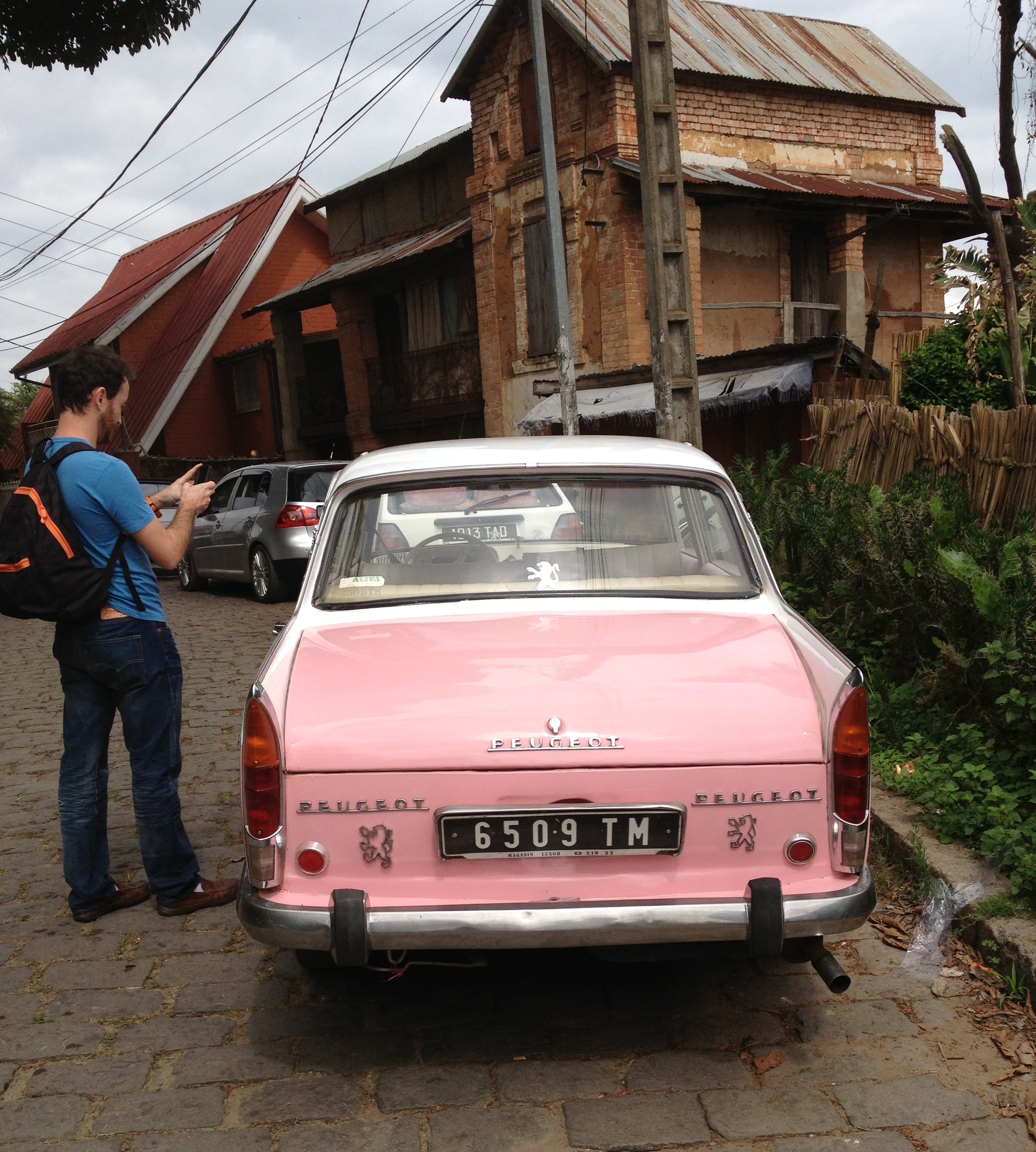
It’s a mesmerizing car window sideshow of small retail establishments—a tire repair shop next to a beauty salon, then a halal butcher, a one-room health clinic, a furniture workshop, a SIM card recharge outlet, a shop selling friperie (second-hand clothes), a small hotel, a lumber yard, a used car parts store, another beauty salon, all crammed into narrow storefronts. Then a wall plastered with posters for music concerts and religious revivals, almost obscuring the Défense d’Afficher (forbidden to post) sign. A jumble of colorful hand-painted signs, mostly in French or Malagasy with a sprinkling of English—Good Auto, Rehoboth Shack, Smile Pizza, Quick Fix Oil Change, Flash Video.

For the last four miles, the road runs along the levee of the River Ikopa. The low-lying areas around Antananarivo are crisscrossed by canals supplying water to the rice paddies. Among the paddies are islands of shacks, with chickens, geese and ducks (some destined to be pâté) running free. Zébu, the humped cattle that are the mark of wealth in rural Madagascar, graze freely on patches of grassland. Then past the 15,000-seater national rugby stadium—home of the Makis (the lemurs)—to a retail district centered, without any sense of ideological irony, on a square dedicated to a communist hero, the Place de Ho Chi Minh.  

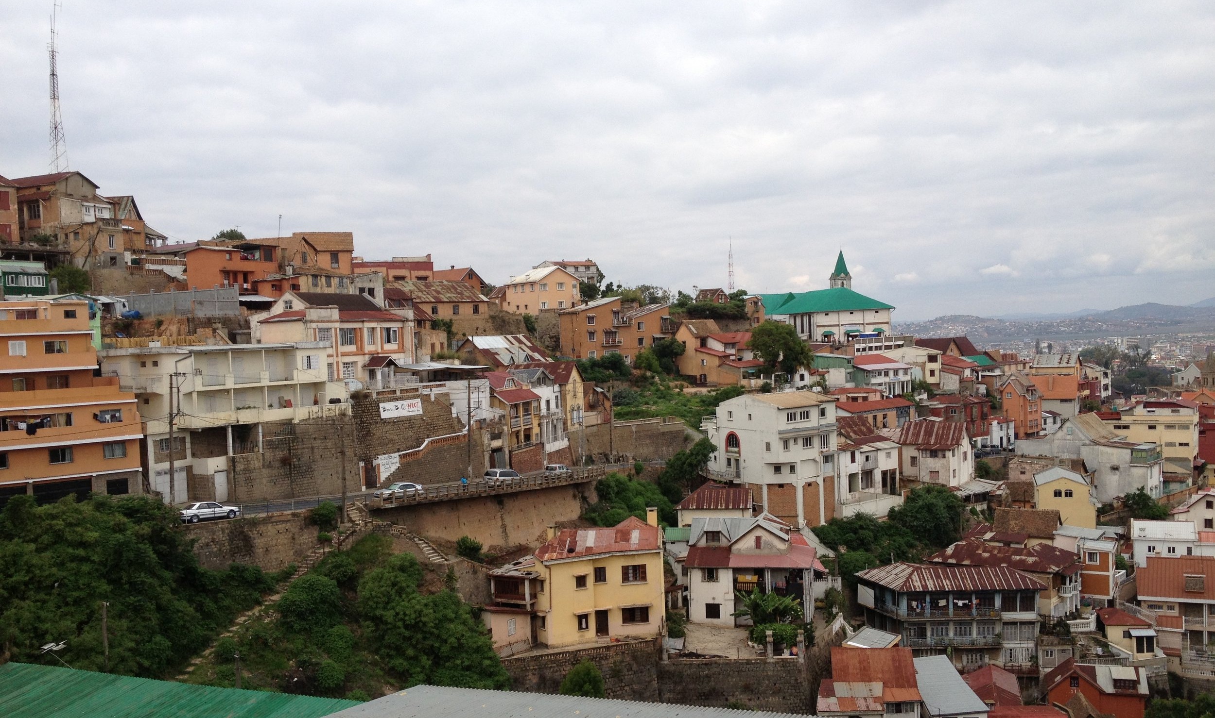
Situated just over 4,000 feet above sea level, Antananarivo—usually abbreviated by both locals and foreigners as Tana—with its hills and narrow, winding streets, feels like a tropical, slightly rundown version of Paris, surrounded by rice paddies.

2.7 Antananarivo hi-res.JPG

From the 8th century AD, the central highlands of Madagascar were settled by the Merina, whose ancestors can be traced to the Malay Archipelago. They brought with them their traditional clan organization and agricultural practices, particularly rice cultivation. Until the French colonized the island at the end of the 19th century, the highlands were a bit like medieval Europe, albeit with nicer weather. Local lords, supported by armed retainers, ruled the villages and rice fields from fortified hilltop positions. Antananarivo was founded in the early 17th century by the chieftain Andrianjaka who built his rova (fortress) high on a hill; in Malagasy, Antananarivo means “city of the thousand,” a reference to the ruler’s army. From the rova, the royal real estate expanded, with new palaces and royal tombs built on the highest points of the ridge.

The residential topography of Antananarivo reflected class distinctions. Down the hill from the palaces were the houses of the andriana, the noble class; the commoners, the hova, lived further down the slope, and the slave caste (andevo) and rural migrants on the plains to the west. Members of castes were required to live in designated districts and return to them after working in other places. Non-nobles were not allowed to build wooden houses or keep pigs within the city limits. As the population grew, the Merina rulers used forced labor to construct a massive system of dikes and paddy fields around the city to provide an adequate supply of rice.

Until the mid-19th century, all houses in Madagascar were built from wood, grasses, reeds and other plant-based materials deemed appropriate for structures used by the living; stone, as an inert material, was reserved for the dead and used only for family tombs. In 1867, after a series of fires destroyed wooden homes in Antananarivo, Queen Ranavalona II lifted the royal edict on the use of stone and brick for construction. The royal palace was encased in stone. The first brick house built by the London Missionary Society in 1869 blended English, Creole and Malagasy designs and served as a model for a new style built in the capital and across the highlands. Termed the trano gasy (Malagasy house), it is a two-story, brick building with four columns at the front that support a wooden veranda. In the late 19th century, these houses quickly replaced most of the traditional wooden houses of the andriana. As Protestant denominations and the Roman Catholic church gained adherents, stone and brick churches were constructed.

In the early 20th century, under French administration, Tana spread out along the lower hilltops and slopes in la ville moyenne (the middle town). In the basse ville (lower town), northwest of the Analakely market area, French urban planners laid out the streets on a grid pattern aligned with a broad boulevard, now called the Avenue de l’Indépendance, with the city’s Soarano railroad station at its northwest end. Engineers drilled tunnels through two large hills, connecting isolated districts; streets were paved with cobblestones, and some later with tarmac; water, previously drawn from springs at the foot of the hills, was piped in from the Ikopa River. Since independence in 1960, urban growth has been largely uncontrolled with the city spreading out across the plains in every direction. In the districts of the basse ville, where roughly-built houses are vulnerable to fire and flooding, residents splice into city power lines to steal electricity. Informal settlements, without adequate water supply and sanitation facilities, have grown up on agricultural land on the outskirts.

Tana+street+scene.jpg

Today, the haute ville retains its late 19th century charm. Trano gasy houses with steeply-pitched tiled roofs, verandas and flowering cactus line the cobbled streets snaking up the hillsides; alleyways with stone steps descend to the Analakely market and shopping streets branching off from the Avenue de l’Indépendance. Among the most impressive buildings are the stone-built churches on the summits. Below the Malagasy Montmartres, people cook over open charcoal fires, draw water from hand pumps, and sleep in doorways. The population of the metropolitan area is close to three million—about one eighth of the total population of Madagascar—but that does not count unregistered migrants from rural areas who arrive every day to work or engage in petit commerce, selling fruits, vegetables, cheap electronics and friperie.

Tana+6.jpg

The French influence is still apparent—in language, the architecture of public buildings, the bakers selling baguettes and croissants, the escargots and pâté de foie gras on the restaurant menus. At the Soarano railway station, the Café de la Gare resembles a brasserie in a French provincial town, with its dark wood paneling, chandeliers, candle-lit tables and white-shirted waiters. The best hotel in the city, the Colbert in the haute ville, founded as a handful of rooms above a café in 1928, reeks of colonial extravagance with its marble-clad lobby, patisserie, hair salon, perfume shop, spa and casino. At the nearby Café du Jardin, overlooking the Analakely market, the large-screen TVs rebroadcast French provincial rugby matches.

The menu at most restaurants is French with a sprinkling of Malagasy fish, poultry and pork dishes, served on a bed of vary (rice).  In one dimly-lit, wood-paneled restaurant, with its long bar, tasteful artwork and attentive waiters, I felt for a moment as if I was in Paris. Then the bill arrived, and I knew I was definitely not in Paris. Haute cuisine at astonishingly low prices. Paris with rice paddies suits me very nicely.

The best road in Madagascar

It’s officially 923 km (577 miles) from Antananarivo, Madagascar’s capital in the central highlands, to Toliara, the main port on the southwest coast, on Route Nationale (RN) 7. All the guidebooks (and every Malagasy I’ve met) say that RN7 is the best road in the country.  It’s all relative, I guess.  I’d classify RN7, a two-lane highway with many one-lane bridges, as a superior county road in Ohio or West Virginia, or maybe a lesser state route in need of maintenance. Yet, for better or worse (mostly for worse), this is the main route to the south. And it doesn’t even go all the way. The southernmost port and city, Tolananro (Fort Dauphin), is another two days’ travel from Toliara on dirt roads (which also have at least the official status of Route Nationales), bone rattling in the dry season and impassable in the rainy season.

FB cover (2) (600x235).jpg
Madagascar map.gif

With Air Madagascar on strike, the only way for me to reach Toliara, where I was scheduled to run a workshop for UNICEF, was on RN7.  We left Antananarivo’s airport mid-afternoon on Saturday and had to spend two nights on the road before reaching Toliara on Monday morning.

Driving on RN7, it sometimes seemed that half the country was on the move. By taxi-brousse (bush taxi), the minivans with luggage, bicycles and the ubiquitous yellow bidons (jerry cans used for carrying water) piled so high that they look as if they will tip over on a curve (they sometimes do).  By auto and bicycle rickshaw.  By bicycle.  On carts pulled by zebu, the humped cattle used for every agricultural task and (with fish) the main source of protein for the population.  Every hour or so we stopped to let a herd of zebu cross the road, the boy herders shouting and waving their sticks.  Outside the towns and villages, there were always people walking along the road.  Rice farmers going to and from their fields. Men with axes and long sticks with curved blades, cutting eucalyptus trees for firewood and charcoal.  Children returning from the river with bidons, lashed onto wooden push-carts, the day’s supply of water for cooking and washing.  Families walking home from church.

Of course, most people in central and southern Madagascar were not on the move. It’s just that those who were traveling were squeezed onto the narrow ribbon of RN7. Outside the towns, I saw only two east-west roads leading off RN7 with a tarmac surface, and who knows how far it went?  The poor infrastructure—primarily the roads, but also rural electricity supply—is the major barrier to economic development in a country where most people are still subsistence farmers, and which lags behind most countries (even many African countries) on human development indicators for health, nutrition, water, sanitation and education. Every rainy season, landslips block the road, and sections wash away, or develop huge potholes. Each administration in this notoriously politically unstable country promises to fix the roads and extend the network but, faced with poverty, hunger and pressing social problems, the promises are soon forgotten. “You can’t eat roads,” remarked our driver dryly.

South of Fianarantsoa, the second largest city, RN7 turns southwest, dipping down out of the highlands to the treeless savanna grasslands.  This is Madagascar’s High Plains country, where herders drive their zebus and sleep out under the stars.  If it wasn’t for the distinctive red and white kilometer posts on the roadside and the absence of pick-up trucks, it could be Wyoming or the Dakotas, the long grass blowing in the wind, the mountain ranges on the horizon.  The grasslands gradually give way to a desert landscape dotted with scrubby trees and cactus, reminiscent of the American Southwest.  

RN7+1.jpg

The wealth in this beautiful but desolate landscape is definitely in them, thar hills—in this case it’s not gold, but sapphires.  Migrants from all over the country have come to this region to seek their fortunes, digging into the hillsides with shovels and pickaxes. They live in rough, single-story shacks in a series of small towns that straggle RN7.  The real wealth is controlled by foreign traders—mostly from Sri Lanka, Pakistan and Thailand—who buy the rough sapphires and sell them, mostly for export.   The names on the gem stores tell the story—Fayez, Najeem, Iqbal, Farook.  These are reportedly wild towns, with high rates of crime and prostitution, where the lucky miner who has just sold his sapphires blows it all on sugar-cane moonshine and the slots at Les Jokers Hotel and Karaoke Bar. 

The final 100 km to Toliara is desolate, and the people poor. In contrast to the rough but functional two-story houses of the highlands, the villages consist of single-room mud huts with thatched roofs and fences of branches and cactus, their occupants literally scratching out a living from the dry, sandy soil.  Finally, we glimpsed the sea in the distance and crossed the low sandy hills into Toliara.  We made it to the Chamber of Commerce just in time for the mid-morning coffee break.  And just in time—my first presentation was on the schedule for right after the break.  


Vive le Renault 4L!

“Do you have a lot of 4Ls in the United States?”

My friend, sociology professor Richard Samuel, asked the question (in French) as our Renault 4L taxi hurtled down a cobblestone hill in Madagascar’s capital, Antananarivo, dodging pedestrians, parked vehicles, and hand carts hauling furniture, metal fencing and sacks of charcoal. It was a jarring, noisy ride. I gripped the door handle which appeared to have been re-riveted to the frame more than once. At the bottom of the hill, the driver crunched into low gear, and began a slow climb.

FB cover (2) (600x235).jpg

I told Richard I had never seen a 4L in the US.  His question puzzled me but, as I looked out at the chaotic traffic, I realized why he had asked. In his urban landscape, the 4L was a dominant species. 

Renault 4L 2.jpg
His pride and joy—a Renault 4L

His pride and joy—a Renault 4L

When I traveled in France in the 1970s, the Renault 4L was a common sight. With its functional, box-like design, it sat high (for its size) on its chassis, its front end inclined downwards as if it was getting ready to dive into the muddy farm fields. It was introduced in 1961, aimed at the lower end of a market dominated by the two-cylinder Citroën 2CV, the celebrated deux chevaux (two horses), a small front-wheel drive saloon marketed as a people's car in the same class as Germany’s Volkswagen Beetle. The 4L, like the 2CV, was seriously under-powered, taking several minutes to reach its preferred cruising speed of about 80 kilometers (50 miles) per hour. Once it made it, it chugged along happily, using much less gas than anything else on the road. The gear shift on the 4L and 2CV was a challenge—you pulled it out directly from the dashboard, then twisted it left and right, forward and backwards, in a complex series of motions. In my 20s, living in Britain, I owned first a 2CV and then the slightly up-market (but no more powerful) Citroën Diane. I soon became expert at the contortions required to shift gears.

Citroën 2CV

Citroën 2CV

I visit my sister and her husband in southwestern France every couple of years. These days, it’s unusual to see a 4L or 2CV on the road, although I’ve spotted a few rusting in barns. But they are still the most common taxis on the roads of France’s former colony, Madagascar. Many are veterans of the traffic wars with battered panels and spectacularly out-of-whack alignment. You try to forget that there’s almost no suspension and just marvel that the car is still running.

The history of the French automobile industry lives and breathes—or rather wheezes—in Antananarivo and other Madagascar towns. I’ve seen other Renault and Citroën models, the Peugeot 204, 304 and 404, and even an occasional Citroën DS (Goddess), the sleek, streamlined car with a hydraulic system that looked years ahead of its time when it was introduced in the mid-1950s.  

Peugeot.jpg

Some have a dodgy electrical system that requires wire-twisting to start the engine.  In Toliara, on the southwest coast, one taxi driver told me the alternator on his 4L had long ago expired; each day, he manually recharged the battery, providing enough juice to start the motor but not enough to run the headlights as he navigated the darkened streets. Another proudly showed me how he could pull the key out of the ignition of his 1990 red Peugeot 404 without any effect on RPM. 

There are gas-guzzling SUVs on the roads of Antananarivo, most of them owned by  politicians, business owners and aid agencies, but in a country where all indicators—unemployment, poverty, health, literacy—put it in the “least developed” category on global indexes, you’re fortunate if you can move up from a zébu (ox) cart to own a 4L or a 2CV. The last ones came off the production line in the early 1990s, but still command high prices on the used-car market, more than $2,000 for a model with a few dents, a cracked windshield and worn seats.

With spare parts no longer available, except from specialty dealers at high prices, how do drivers keep their cars running? The answer is bricolage (from the French verb bricoler, to tinker), loosely translated as do-it-yourself. The auto parts trade, Richard said, is controlled by Indian and Pakistani shopkeepers who import parts from factories in Mumbai and Karachi. Many either fit the old cars or can be made to fit with a little bricolage. For that service, you go to a metal fabrication shop that cuts and welds made-to-order fencing, pipes, market stall frames, and agricultural implements. They can take a Tata or Mahindra part and make it work for your 4L; if not, they’ll just make you a new part. When cars eventually break down and cannot be repaired, the parts are salvaged and resold. “In this economy, there’s almost always a new use for something,” said Richard.